Tuesday, May 29, 2007

2007-05-28 Rattlesnake Ledge

4.0 mile round trip
Map offline: Green Trails Maps™ No 205S
Map online: TerraServer USA
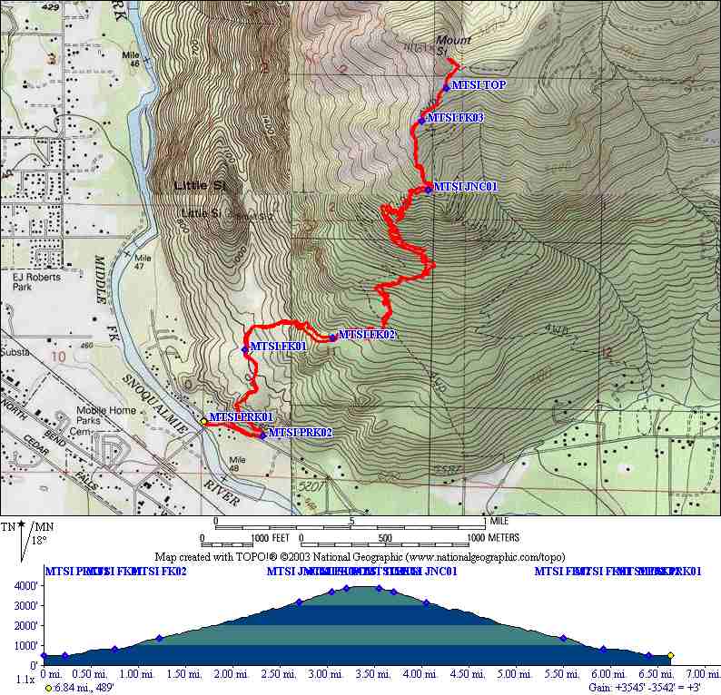
Trailhead coordinate: Lat: 47.435171, Long: -121.768513; Alt: 920 ft.
Elevation gain: 1,159 ft.
Max elevation: Lat: 47.436111, Long: -121.778734; Alt: 2,079 ft.
Hike time: up ↑ 1:00; break ↔ 0:15; down ↓ 0:40; Total ⇅ 1:55
Effort: Relaxed
Trail difficulty: Easy


Matt, John, and I went on a quick jaunt up Rattlesnake Ledge near the conclusion of the holliday weekend. This trail is an old stand-by, with a well maintained path and excellent views. Here are some shots from the hike:


A small rock. Aren't you glad you weren't there when that came tumbling down the mountain?


The view of Rattlesnake Lake from a lookout on the way up.


Mount Si (and little Si next to it) looms in the distance.


A mountain vista from the Ledge.


It was a party up there! Not the most crowded I've seen it, but close.


John pauses to get his picture taken.


Not framed exactly how I wanted it, but some pretty colors. Notice the shadow of Rattlesnake ledge down onto the lake.


Another mountain vista. Wow, I really got carried away with the pictures today.


Since I brought the big lens... Check out the wakes these swimmers created.


Matt makes secret contact with the man in charge.


I have no idea who this person is, but they appear to be thinking about something important.


The last of the mountain vistas, I promise. Probably the best pic of the bunch too.

Rattlesnake ledge is a really rewarding, and very accessable hike. I highly recommend it!

Monday, May 28, 2007

2007-05-26 McClellan Butte

9.2 mile round trip (7.5 miles completed)
Map offline: Green Trails Maps™ No 206S
Map online: TerraServer USA
Trailhead coordinate: Lat: 47.4113690, Long: -121.586766; Alt: 1580 ft.
Elevation gain: 3,582 ft. (2,620 ft. completed)
Max elevation: Lat: 47.406869, Long: -121.622176; Alt: 5,162 ft. (4,200 ft. reached)
Hike time: up ↑ 2:45; break ↔ 0:30; down ↓ 2:00; Total ⇅ 5:15
Effort: Steady
Trail difficulty: Most Difficult

Forest Service Link

John and I set out to do McClellan Butte this Saturday. It turned about a bit ambitious, as we were not able to summit.

To start off the hike, we headed down I-90 with only an exit number (42.) Turns out you just turn right and follow the signs. Another thing you need to know is that McClellan Butte requires a "Northwest Forest Pass". We did not realize this in advance, and so had to take our chances.

The weather was terrific (70 degrees in the sun, even at altitude.) That, however, was some of the problem. With the melting snow, we had a hard time finding enough tracks to follow the trail. On top of that, I was concerned about avalanche. Above about 3,000 feet, there was snow the whole way. After feeling like we had lost the trail since we had had gone straight for a very long time (no switch backs) we decided to turn around. We made it to 4,200 feet according to GPS, and by that time, there was about 10 feet of snow!

After the hike, we went to REI to pick up a Northwest Forest Pass ($30 annual.) We also found some up to date info on the state of various climbs. For McClellan Butte, "Extreme Avalanche Danger" was written in bold red print. Well, all is well that ends well, but next time, I'm bringing a shovel!

We'll certainly do this one again when it is either colder or warmer.


A rocky path on the way up. John and I suppose these small rocks were created by glaciers. What do you think?


At the top of the picture you can see the summit. In the middle is a waterfall, and at the bottom is where we're standing. Read: Avalanche danger.


John standing on a snow field to get a GPS reading while I stand safely (?) by the trees. This shot gives you a nice perspective on how steep this climb was in many places. Also, though John is in shorts, we were quite warm. It was nearing 70 degrees when we were in the sun.


Ye olde GPS. Tells us we made it to 4191. The longer we looked at it the higher we got. Leading to the famous statement, "Well hell, if we just stand here, we'll make it all the way to the top."


One of the Vistas from a snow field.


Here you can see the aftermath of prior avalanche. We are standing well uphill of this site, and we didn't see it happen.

Another waterfall in an avalanche gully. Here you have a very clear view of the summit.


John photographs the waterfall.


Yikes! And we just walked on top of that! To underscore the melting snow point, here is the rushing water visible through an ~8 foot hole in the snow.

Tuesday, May 22, 2007

2007-05-19 Mt. Si (Old Big Si Trail)

7.0 mile round trip (Old Big Si Trail 2.4 mi via Little Si Trail 0.5 mi and Boulder Garden Loop Trail 0.6 mi)
Map offline: Green Trails Maps™ No 206S
Map online: TerraServer USA
Trailhead coordinate: Lat: 47.486962, Long: -121.754866; Alt: 500 ft.
Elevation gain: 3,667 ft.
Max elevation: Lat: 47.507778, Long: -121.738889; Alt: 4,167 ft.
Hike time: up ↑ 3:00; break ↔ 0:05; down ↓ 1:40; Total ⇅ 4:45
Effort: Hard
Trail difficulty: Difficult

A work associate of mine, Andrei, told me about the Mt. Si old trail. It's steeper than the main trail but ends up at the same place. Jon P and I completed the whole hike in 4:45. It took us 3 hours to get up and the remainder down. Pretty good time for me!


USGS map.


The Snoqualamie river bends around Mt Si.


North bend. Clearer this time than last.


Consider it conquered!


John reflects on North Bend, life.


2007-05-17 Little Si

4.2 mile round trip
Map offline: Green Trails Maps™ No 206S
Map online: TerraServer USA
Trailhead coordinate: Lat: 47.486962, Long: -121.754866; Alt: 500 ft.
Elevation gain: 1,076 ft.
Max elevation: Lat: 47.498889, Long: -121.754722; Alt: 1,576 ft.
Hike time: up ↑ x:xx; break ↔ x:xx; down ↓ x:xx; Total ⇅ x:xx
Effort: Relaxed
Trail difficulty: Easy

Matt and I took a stoll up Little Si after work on Thursday last week. After doing Mt. Si the previous weekend, this was an easy one. Here are some shots from along the way:


A rock climber takes it slow up a 90 degree face.


An interesting bush at the top of Little Si.

Little Si's big brother.


View from Little Si. That's Rattlesnake Ledge in the distance. Interestingly, I haven't done that hike yet this year. Consider it reserved for an after work hike like this one.